|
| GPS Track |
Date: 01/06/2013
From: Langdale NT Campsite
Parking: Langdale NT Campsite
Start Point: Langdale NT Campsite
Region: Southern Fells
Route length: 9.9 miles (14.5km)
Time taken: 05:54
Average speed: 1.7mph
Ascent: 1422m
Descent: 1433m
Wainwrights on this walk: Bowfell (902m), Crinkle Crags (859m), Pike O’Blisco (705m), Cold Pike (701m)
Additional summits: Great Knott (696m)
Other points of interest: Whorney Side Force, Hell Gill, Climbers Traverse, Bowfell Buttress, Bad Step, Wrynose Fell
Route: Langdale NT Campsite, Stool End, Oxendale, Whorney Side, Hell Gill, Buscoe, The Band, Flat Crags, Bowfell Buttress, Bowfell, Bowfell Links, Three Tarns, Shelter Crags, Crinkle Crags, Bad Step, Great Knott, Cold Pike, Red Tarn, Pike O’Blisco, Wrynose Fell
Having climbed Bowfell in the past, I jumped at the chance to join a group of like minded friends for a weekend in Langdale tramping around the fantastic skyline of Langdale. As head organiser, Skip had proposed a classic route around the high peaks at the head of the Langdale valley while managing to avoid many of the more well trodden paths like The Band and the path down Browney Gill. Considering the fantastic weather, we did well not to bump into too many other walkers which is a surprise as Langdale probably offers some of the finest walks in the Lake District and this trip was one not to be missed.
Contrary to popular belief, the weather was fine and bright as we set off, with no forecast of any real rain. That’s right. The forecast was for a dry, sunny day. The kind of day that would do justice to this magnificent part of our country.
 |
| Pike of Blisco looking splendid in the morning sunshine |
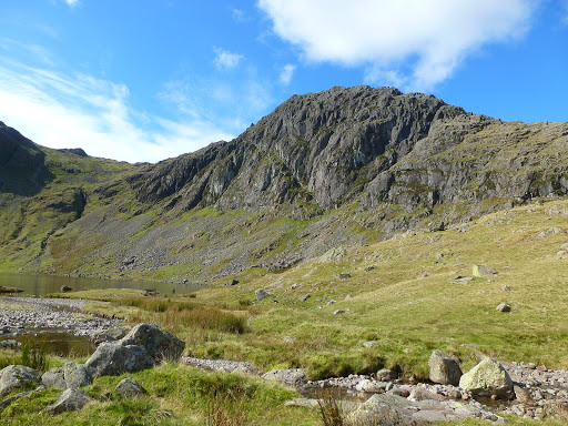
Leaving the campsite, we made our way along the road to Stool End Farm before avoiding the start of The Band by heading up Oxendale towards Whorney Side. Oxendale Beck sits between The Band and Pike O’Blisco with Crinkle Crags towering above it at the head of the valley. Several streams (including Crinkle Gill and Buscoe Sike) flow into Oxendale Beck before it meets Mickleden Beck further down the valley.
 |
| The classic Crinkle Crags as viewed from Oxendale |
Continuing up Oxendale, a brief climb up alongside Buscoe Sike leads you to Whorneyside Force, a secluded waterfall with a lovely deep plunge pool that allowed us to have a quick break and scamper around the steep sides.
 |
| Buscoe Sike and one of its many smaller waterfalls |
 |
| The tumbling water at Whorneyside Force |
After leaving the falls behind, we made a steep climb back out of the valley to re-join the main path as it heads further up the flanks of Buscoe Sike towards Hell Gill. Hell Gill is a striking gorge, carved into the side of the hill by the force of the water. Iain, being the adventurous type, opted the scramble straight up the ravine whereas the rest of us, being a bit more cautious looked on, meeting him at the top. You can see his pictures here.
 |
| Iain negotiates the scramble up Hell Gill |
 |
| Looking down Langdale from the path above The Band |
After reaching the top of Hell Gill, we detoured again to cut across the hillside to meet the popular path up The Band. This was in aid of reaching the Climbers Traverse, my absolute favourite part of this walk. It’s said that only 1 out of every 100 walkers who climb Bowfell traverse the climbers route which is a real shame as it is great fun. It does however, keep it reasonably quiet. The traverse is perched on the flanks of the northeastern face of Bowfell and is probably the easiest route to Bowfell Buttress, a popular climbing face. I’ll let the pictures below tell the rest of the story.
 |
| Starting out along the traverse with Langdale in the background |
 |
| Bowfell Buttress can be seen in the background |
 |
| The gang round one of the trickier parts of the path though it offers no real difficulty to most walkers |
 |
| Bowfell Buttress stands proud at the end of the traverse |
Having crossed the traverse our group split up at go separate ways to the summit of Bowfell. Some climbed the boulder fall next to the Great Slab while Skip, Iain and myself continued across to the foot of the Buttress to see what was what.
 |
| Looking up Bowfell Buttress |
 |
| Bowfells famous Great Slab as seen from the Buttress |
As I’d climbed the boulder fall before (to the right of the Great Slab in the picture above), we decided to climb up the scree directly next to the Buttress. This was a tough little climb, partly due to the looseness of the stones and partly due to the rising temperatures as we crept into the afternoon.
 |
| Looking down the scree into Mickleden |
Reaching the top of the scramble, the brisk breeze was a welcome antidote to the exertion of the climb. All that remained was a quick scamper up to the summit of Bowfell. At 902m, Bowfell is the sixth highest peak in the Lakes and very popular with walkers. We were quite lucky that we were among only a handful of others on the summit at the time we arrived and we had it to ourselves once the few people who were there went their separate ways. The views from Bowfell are special as you can see every major group of fells topped off by an inspirational view of the Scafell range.
 |
| The Scafells from the summit of Bowfell |
 |
| The summit of Bowfell with Crinkle Crags in the distance |
After meeting up with the rest of our group, we started our descent from the summit, heading down towards Three Tarns and Crinkle Crags, not before having a nose down Bowfell Links, the distinct vertical scars you can see in the picture below. After a brief lunch stop, we started the rollercoaster ride over Crinkle Crags, one of Wainwright’s particular favourites. It is from here that you get the iconic view of Bowfell, sat next the Scafell range. It really is an awesome sight.
 |
| Scafell, Scafell Pike, Broad Crag and Bowfell |
We all made our own, slighty different ways over the five Crinkles, such is the nature of them, but we were sure to stop off at Long Top, the highest of the five mini peaks at 859m. Before long we reached the infamous Bad Step, a 10ft declivity that is described by Wainwright as the most difficult obstacle on any of the regular walkers routes. It’s fair to say that I made a bit of a meal climbing down the Bad Step last year, however this year, the short scramble down the face suddenly seemed very obvious so, down I went. Skip and Smokey managed to find the way around with the dog, as described in Wainwrights guide, before Skip, Smokey and I made sure we were Bad Step experts by climbing it, descending it, climbing it again before going around it and continuing on. Never again will I be caught out by it.
 |
| Crinkle Crags and Bowfell |
 |
| Iain snaps away as Craig makes the Bad Step look easy |
After the excitement of the Crinkles and Bad Step, we opted for another quick break before crossing the flat, open hillside towards Pike O’Blisco. While the group headed down the path, Skip and I nipped over to Great Knott before crossing the path and climbing Cold Pike to help me add another Wainwright to the list. Reaching Red Tarn, the majority of our gang opted to head back to the campsite down the path next to Browney Gill while Skip, Smokey, myself and the dog (begrudgingly) started the steady climb up to the summit of Pike O’Blisco. I’d never been up Blisco and I was in for a real treat as it has a fantastic summit, crowned by a dual peak that is separated by a sheltering gully. The views from the summit are amazing as well as the picture below shows.
 |
| Langdale panorama from the summit of Pike O’Blisco |
 |
| The twin peaks of Pike O’Blisco |
All that remained was a steep descent down the well laid path across Wrynose Fell, into the valley of Redacre Gill. By now I was starting to fell the exertion in the legs but before long we reached the road and made it back to the campsite.
 |
| Smokey and Ella contemplate the steep descent |
All in all this was a tiring but extremely enjoyable walk and contains some of the great moments a walker can experience when climbing the Lakeland fells. I’d recommend this route to anyone wanting to experience the Lake District and would urge those of you considering visiting Langdale to make plans visit soon. It seems that it will take something very special indeed to knock Bowfell and Langdale from the very top of my list of favourites.